They say there is only one male river (rivers are considered female in India) and that is born in the Tibetan highlands. Of course, the name itself identifies it as the son of Lord Brahma ~ the creator of the universe according to Hindu mythology. Brahma’s son (putra in Hindi) is known as Brahmaputra, the sacred river that emerges as a unique identity for the people of Assam.
Even though the Brahmaputra is an international river connecting Tibet (now under China), India and Bangladesh, it is omnipresent in the great Assamese literary-cultural pieces. Often the mighty river is called Luit in Assamese literature and Assam’s greatest son of recent times, Bhupen Hazarika, described it as Burha (literary meaning old) Luit also.
Many of Hazarika’s immortal creations are related to the Brahmaputra (pronounced in Assamese as Brohmoputro). In different songs, the legendary singer terms the river as a symbol of greatness, harmony and assimilation. At times, the celebrated music composer also questioned, “Why does it flow in spite of the endless sufferings of dwellers in both of its banks?”
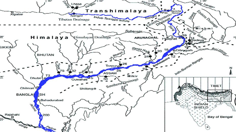
The powerful river originates from the Jima Yangzong glacier in Tibet (at an elevation of about 5,150 metres), flows across southern Tibet and enters Arunachal Pradesh. It then flows south-west through the Assam valley to penetrate into Bangladesh. Finally, the gigantic river culminates in the Bay of Bengal after merging with the Padma and Meghna rivers.
Identified as one of the major rivers of Asia (the world’s fourth largest), the Brahmaputra is known as Tsangpo in Tibet (Yarlung Zangbo in Chinese), Siang or Dihang in Arunachal and Jomuna (not Yamuna of north India) in northern Bangladesh. It covers nearly 2,900 km and embraces a basin area of around 6, 51,300 square km. The river, occasionally adored as a sea, discharges an average of 19,300 cubic metre volume of water per second.
Often called Tsangpo-Brahmaputra, it is perhaps the only river in the world that is regarded as holy in four religions (Hinduism, Buddhism, Jainism and Bon). But the river with an average width of three km (maximum 10 km) in the plains and a depth of 40m (maximum 120m) is prone to catastrophic flooding when the Himalayan snow melts every summer and monsoon rains sweep the valleys.
It has a number of tributaries — namely Raka Tsangpo, Kyi, Gyamda, Nyang Chu, Jiadhal, Subansiri, Siang, Dibang, Kameng (or Jia Bhoroli), Aie, Dikhow, Dhansiri, Kopili, Digaru, Puthimari, Pagladiya, Dudhnai, Saralbhanga, Manas, Sankosh, Tista, Raidak, Torsa, Jaldhaka et al — which help it swell in the rainy season and inundate the valleys. Unlike other parts of India, where four distinct seasons (summer, monsoon, autumn and winter) are observed, the Brahmaputra valley enjoys six ritus (seasons) namely grisma (summer), barsha (rainy or monsoon), sarat (autumn), hemanta (pre-winter), seet (winter) and basanta (spring).
In eastern Assam, the majestic river divides into two channels (the northern one is named Kherkutia and southern one, Brahmaputra) and later joins again, around 100 km downstream, to form the unique Majuli Island. It must be mentioned that Majuli is recognised as the largest human inhabited freshwater island in the world. It is also the epicentre of neo-Vaisnavite culture, which was propagated by the 15th century Assamese saint, philosopher and spiritual guru, Shrimanta Shankardev.
The Brahmaputra, Ganga (known as Podda in Bangladesh) and Meghna create thousands of small and medium-sized river islands, popularly called as char (both in Assamese and Bengali). The islands give shelter to thousands of poor families, most of who survive without any modern day facility. Sandy in character, many islands disappear during the monsoon floods, forcing the dwellers to move to safer places. The chars in western Assam are dominated by Bengali Muslims (migrants from erstwhile East Pakistan) — they depend on agriculture and maintain communication with the mainland through small boats or motorised ferries. An unabated growth of population, low literacy, poor infrastructure and inadequate livelihood opportunities make the dwellers vulnerable.
The smallest one, but inhabitable, Brahmaputra island is named Umananda, which is situated in the greater Guwahati area. North of the pre-historic city, the rock-based island (also also known as Peacock Island) is home to an important Shiva temple, which was built in the middle of the majestic river at the end of the 16th century. The narrowest part of the Brahmaputra falls in Guwahati, where the Saraighat rail-and-road bridge was constructed in the 1970s to connect the southern part of it to the rest of India. As an aside, it has historical significance as the great Battle of Saraighat was fought in the locality in 1671, where the Assam (then Ahom) forces, under the leadership of great warrior Lachit Borphukan, defeated the Mughal invaders.
One of the widest rivers in the world, the Brahmaputra not only supports millions of human habitations in its basin but also embraces various historic destinations, religious places, forest reserves, tea plantations and water bodies attracting river dolphins and numerous migratory birds from different parts of the globe. People take regular ferry services (also machine boats) to cross the river for daily needs and also for joy rides in Guwahati.
The river is not always loved — it is also feared as a destructor. Therefore the people of Assam worship it as a deity. Many songs by Hazarika depict the river in different moods — in one, the legendary singer put the Brahmaputra as a symbol of assimilation while in another he reprimanded the “son of the creator” for its indifference to people’s endless suffering.
In the past three centuries, the river has changed its course drastically. The more recent happening has been traced in 1950, when a massive earthquake jolted the entire Brahmaputra basin. The bed levels of many rivers including the Brahmaputra were raised due to the tremor. It resulted in a perennial flood and erosions across the basin, rendering thousands of families homeless due to loss of their villages and cultivable lands.
With the aim of addressing the recurrent flood problems, the Union government established the Brahmaputra Board in 1980. The board, whose jurisdiction covered the Barak valley too, was entrusted with the responsibility to prepare a master plan for controlling the flood and erosion while also improving rain water drainage, tapping hydropower potential and irrigating the arable lands in the valley.
If India was shying away from fully exploiting the hydro-electric potential of the river (estimated to be around 66,065 mega watts), the Chinese government initiated an undisclosed number of hydropower projects inside Tibet. The recent operationalisation of the Zangmu hydropower station in the upper course of the Brahmaputra raised apprehensions that Beijing would continue constructing dams for electricity and even divert the river to irrigate the country’s water-starved southern part.
The development had political implications as memories of the 1962 Chinese aggression through the Arunachal border still hunts people in North-east India.
(The writer is the Guwahati-based special representative of The Statesman)
Advertisement