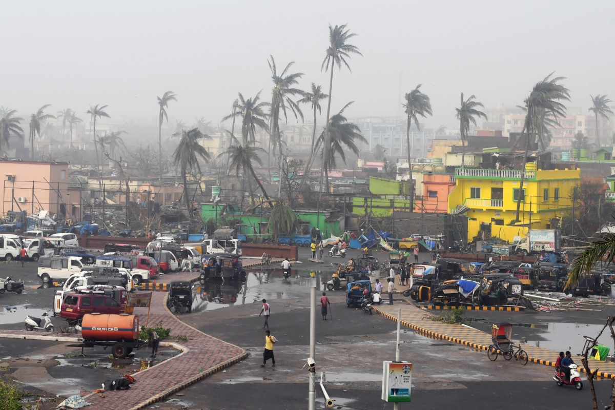
The season of disasters began this year with the tempestuous cyclone “Tauktae” hitting the west coast, then “Yaas” and now “Gulab” across the east coast of India disrupting life and the local economy in the affected regions.
Natural disasters like cyclones, monsoons, and the consequent floods are known to cause loss of lives and tremendous damage to public property and livelihoods. Farmlands get inundated and crops worth millions of rupees get damaged. Houses collapse. Trees and electric poles get uprooted.
Overall, natural disasters paralyse the local economy for a long time unless the post-damage assessment is precise and quick, and timely relief is distributed to the needy. Quite often, different government organizations at local, state and federal level dispatch their teams in convoys to the cyclone and flood-affected regions for verification of the scale of the disaster so that the governments can extend financial help to the needy as early as possible. This is the norm followed since the past century.
However, the movement of teams towards the disaster areas generally causes a time lag i.e., the time when a disaster strikes an area to the time when the disaster assessment team visits the affected area. This can extend to 3-4 weeks or even more because it requires time to constitute the teams; plan and arrange logistics for physical verification of the disaster areas.
The convoys mostly depend on visual inspection, photographs and videos, but there is no guarantee of accuracy of either such data or that furnished by locals and local authorities. Rather it can lead to erroneous damage assessment.
Consequently, considerable time, and more importantly considerable data could be lost by the time the teams physically reach the affected areas because the data related to damage is dynamic.
For example, inundation might get reduced within a week due to the drainage of water or evapotranspiration. The affected crops might have regrown in 2-3 weeks. People might have altered the affected water bodies, removed fallen trees or electric poles, and repaired the damaged houses as temporary measures. Locals and local authorities can manipulate and exaggerate the damage for want of relief ~ all of which could increase the burden on the governments.
Moreover, crisscrossing the disaster zone that extends to hundreds of square kilometres is a serious limitation. To inspect and assess damage in such a vast area that stretches from few hundreds to thousands of square kilometres within 3-4 days is nothing short of hubris. The travel and logistic expenses of the convoy will simply escalate and that itself could be enormous. This is ironic given the fact that the purpose of the post-damage assessment is to provide quick relief to the needy at the earliest.
So, the centuries-old model of physical verification of the affected areas is rudimentary. It could reduce the effectiveness of post-damage assessment and may increase the cost to the exchequer.
Hence, there is a need for a paradigm shift towards technology-driven assessment in 21st century India.
India has made tremendous strides in remote sensing (RS), Geographical Information systems (GIS), and information technology in the past several decades. However, the use of RS & GIS techniques in post-disaster assessment is limited or rather confined to research studies. And the nation is yet to master robotics and AI (Artificial Intelligence) in post-disaster damage assessment.
Remote sensing technology used to its fullest capacity can overcome or minimize the drawbacks of time lag and post damage assessment of cyclones and other disasters more precisely by working remotely and instead of convoys crisscrossing hundreds of square kilometres. (Else, what use are all of our space achievements?)
India has a fleet of operational earth-observation satellites such as Cartosat-3 capable of delivering cutting-edge high spatial resolution images of less than 30 cm. A combination of remote sensing data involving synthetic aperture radar (SAR) images, optical satellite and aerial images, thermal images, airborne laser scanner (ALS) data, land-based mobile mapping data, and unmanned aerial vehicle (UAV) data can be utilized to accurately demarcate the real extent of damage to crops, inundation of agricultural land, the damaged houses, damaged electric poles, and inundation of settlements.
Perhaps, the most important benefit of radars such as Synthetic Aperture Radars (SAR) in earth observation is that the microwaves can penetrate clouds; and images can be obtained in all weather conditions. Stressed or damaged crops experience a decrease in chlorophyll content and changes to the internal leaf structure. The approach is to examine the time series of crop conditions observed throughout a growing season after a flood event is outlined by various scholarly studies.
There are methods of automatically extracting house damage information from post-disaster high-resolution optical remote sensing imagery through the multi-scale fusion of spectral and textural features.
Airborne laser scanning (also called LiDAR) is an important data acquisition approach. Backscattering of transmission towers and lines can be identified using a combination of X-band SAR images, machine learning and computer vision methods. The proposed method automatically captures the current pole inclination angles using an unmanned aerial vehicle.
Therefore, with a combination of technology-driven platforms such as satellites, fixed-wing aircraft, helicopters, unmanned aerial vehicles (UAVs) and ground vehicles, the damage assessment of post-disaster affected areas can be done remotely with much better speed and accuracy than the convoy of teams crisscrossing the countryside. Such remotely collected data through RS and GIS techniques enhances data accuracy as these techniques allow exact measurements, repeated analyses and long-term storage for comparison of data over time. In fact, the physical verification can be limited to ground truth verification.
The technology thus reduces the crucial time lag, evaluates the post-disaster losses in less time and with less cost due to which compensation could be estimated more accurately, so that the relief can be supplied to the needy at the earliest. If planned properly, it can eliminate all the drawbacks of the convoy system of physical verification.
Natural disasters emanating from tempestuous cyclones and monsoons are inevitable. However, it is the speed with which the relief reaches the needy during and after the time of disaster that determines the resilience of the affected to such disasters.
Hence, it is time for a paradigm shift in India towards technology-driven post-disaster management that should be in line with the nation’s technological accomplishments instead of unreliable, inaccurate, expensive and rudimentary physical verification methods.
Advertisement