On Sunday, Maximum Temperatures were 42-45°C over most parts of Vidarbha, West Madhya Pradesh, Rajasthan; in isolated pockets over Gujarat state, and 40-42°C over most parts of East Madhya Pradesh, north Madhya Maharashtra, Marathawada; in some parts of south Haryana, Rayalaseema and in isolated pockets of Punjab, south Uttar Pradesh, Jharkhand, Chhattisgarh, Telangana and interior parts of Odisha.
✔ Heat Wave conditions were observed in many parts of West Rajasthan.
Advertisement
✔ Chief amount of rainfall (in cm): Coastal Andhra Pradesh: Vishakhapatnam: Narsipatnam-9, Bihar: Muzaffarpur-9, Supaul-8; Tripura: Zunhoboto-8; Andaman-Nicobar Islands: Long Island-6, Tamilnadu: Nilgiris: Uthagamandalam-6, Erode: Perundurai-5, Coimbatore: Pollachi-5; Assam: Silchar-6
Advertisement
✔ Isolated heavy rainfall observed over Tripura, Bihar and Coastal Andhra Pradesh.
✔ Thundersquall reported at isolated places over Andaman Islands.
Maximum Temperature forecast and Heat Wave warning:
✔ Rise in maximum temperatures by 2-3°C very likely over south Punjab, south Haryana-Delhi, Rajasthan and north Madhya Pradesh during next 4 days and no significant change thereafter. ✔ No significant change in maximum temperatures very likely over rest parts of the country.
Heat wave conditions:
Heat Wave conditions very likely in isolated/some pockets over:
✔ Rajasthan during 09th-13th May with isolated severe heatwave conditions over West Rajasthan during 10th-12th May
✔ Gujarat state on 09th & 10th May
✔ Vidarbha & Madhya Pradesh during 09th-13th May
✔ south Haryana & south Punjab during 10th-13th May and over Delhi during 11th-13th May, 2022.
Weather System:
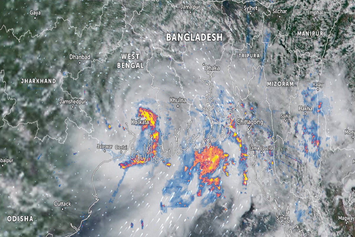
Yesterday’s cyclonic storm ‘Asani’ (pronounced as Asani) over Southeast Bay of Bengal intensified into a Severe Cyclonic Storm over the same region at 1730 hrs IST of 08th May. It moved nearly west-northwestwards with aped of 25 kmph during past 06 hours and lay centered at 0830 hours IST of today, the 09th May, over Westcentral & adjoining south Bay of Bengal near latitude 14.0°N and longitude 86.0°E, about 920 km northwest of Car Nicobar (Nicobar Islands), 770 km west-northwest of Port Blair (Andaman Islands), 500 km southeast of Visakhapatnam (Andhra Pradesh) and 650 km south of Puri (Odisha).
It is very likely to move northwestwards till 10th May and reach Westcentral and adjoining Northwest Bay of Bengal off North Andhra Pradesh & Odisha coasts. Thereafter, it is very likely to recurve north northeastwards and move towards Northwest Bay of Bengal off Odisha coast. It is likely to weaken gradually into a Cyclonic Storm during next 48 hours.
Warnings associated with Severe Cyclonic Storm ‘Asani’:
(i) Rainfall (warning graphics enclosed)
9th May: Rainfall at a few places is very likely over coastal Andhra Pradesh.
10th May: Light to moderate rainfall at a few places with heavy to very heavy rainfall at isolated places is likely over coastal Andhra Pradesh and heavy rainfall at isolated places is likely over coastal Odisha from the 10th evening.
11th May: Light to moderate rainfall at a few places with heavy to very heavy rainfall at isolated places is likely over coastal areas of north Andhra Pradesh and heavy rainfall at isolated places is likely over coastal Odisha & adjoining coastal West Bengal.
12th May: Light to moderate rainfall likely at a few places with heavy rainfall at isolated places is likely over coastal areas of Odisha and West Bengal.
(ii) Wind warning
⮚ 9th May: Gale wind, speed reaching 100-110 kmph gusting to 120 kmph prevailing over Westcentral and adjoining South Bay of Bengal. It would gradually decrease becoming 90-100 kmph gusting to 110 kmph over Westcentral Bay of Bengal.
⮚ 10th May: Gale wind speed reaching 85-95 kmph gusting to 105 kmph is likely to prevail around the system center over Westcentral Bay of Bengal. It would gradually decrease becoming 70-80 kmph gusting to 90 kmph over Westcentral and adjoining Northwest Bay of Bengal. Squally wind speed reaching 40-50 kmph gusting to 60 kmph is likely along and off north Andhra Pradesh coast.
⮚ 11th May: Gale wind speed reaching 70-80 kmph gusting to 90 kmph is likely to prevail over Westcentral and adjoining northwest Bay of Bengal. It would gradually decrease becoming 60-70 kmph gusting to 80 kmph over northwest and adjoining Westcentral Bay of Bengal. Squally wind speed reaching 40-50 kmph gusting to 60 kmph is likely along and off north Andhra Pradesh and adjoining Odisha coasts.
⮚ 12th May: Gale wind speed reaching 50-60 kmph gusting to 70 kmph is likely to prevail over northwest Bay of Bengal. It would gradually decrease becoming 40-50 kmph gusting to 60 kmph from evening. Squally wind speed reaching 40-50 kmph gusting to 60 kmph is likely along and off Odisha coast.
(iii) Sea condition
∙ 9th May: Very High Sea condition is likely to prevail over Westcentral and adjoining South Bay of Bengal.
∙ 10th May: Very High Sea condition is likely to prevail over Westcentral & adjoining Northwest Bay of Bengal.
∙ 11th May: Sea condition is likely to become high to very high over Northwest and adjoining Westcentral Bay of Bengal.
∙ 12th May: Sea condition is likely to become high to very rough over Northwest Bay of Bengal and improve thereafter.
(iv) Fishermen Warning (Graphics enclosed)
∙ Fishermen are advised not to venture into Westcentral and adjoining South Bay of Bengal on 9th May, into westcentral Bay of Bengal on 9th & 10th and into Northwest Bay of Bengal during 10th to 12th May. ∙ Fishermen out at sea are advised to return to coast.
Rainfall/thunderstorm Forecast & Warnings:
Fairly widespread to widespread light/moderate rainfall with thunderstorm/lightning/gusty winds very likely over Northeast India during the next 5 days. Isolated heavy falls are very likely over Arunachal Pradesh & Assam-Meghalaya from 10th-13th and over Nagaland-Manipur-Mizoram-Tripura from 09th-13th May. Isolated very heavy rainfall also likely over Assam-Meghalaya from 11th-13th May.
Scattered to fairly widespread light/moderate rainfall very likely over Kerala-Mahe, Lakshadweep, Coastal Andhra Pradesh, and Coastal & South Interior Karnataka and isolated to scattered rainfall activity over Telangana, Rayalaseema, North Interior Karnataka & Tamilnadu, Puducherry & Karaikal during next 5 days. Isolated thunderstorm/lightning/gusty winds over the region during the next 2 days. Isolated heavy rainfall likely over Tamilnadu and Kerala on 09th May.
Advertisement