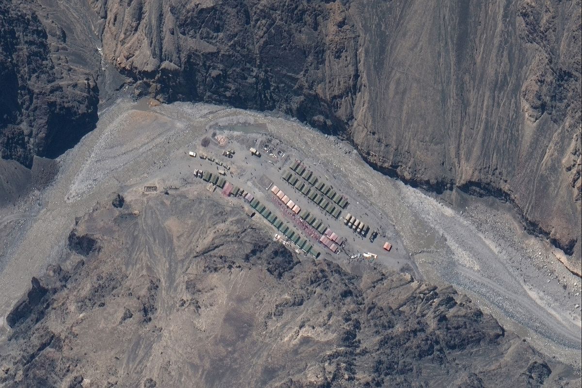
China is building bunkers and underground facilities in Aksai Chin around 70 km from the Line of Actual Control, according to reports citing Maxar Technologies satellite images. The Chinese have also ramped up construction in the region in an effort to better protect its military facilities and personnel from ariel strikes. The analysis of the Maxar satellite images has revealed that China has constructed reinforced personnel bunkers at four locations and tunnels are being dug at three more locations. A few portals, probably tunnel openings, are also visible in the satellite images.
The comparison between satellite images of August 2021 and August 2023 also shows large structures have been built in the area in the last two years. There is a separate entry and exit area and the pre-existing road has also been widened. China has also increased the deployment of military personnel in the area and erected several tents.
Advertisement
According to military experts, the Indian Air Force has an extra advantage over China in the Aksai Chin region and the dragon is trying to take that away by constructing reinforced personnel bunkers and tunnels. Beijing wants to better protect its military assets in the region in the event of an aerial strike by India.
India and China have been locked in a territorial dispute over Aksai Chin since the 1950s. While Aksai Chin is part of India, China falsely claims it falls in their territory. In May 2020, the two nuclear-armed neighbours came to the brink of a full-fledged war after their armies indulged in a melee along the LAC. Several Indian and Chinese soldiers were killed during the standoff.
Both countries claim they want a peaceful resolution to the Ladakh border dispute, but China’s absurd claims on Indian territories are undoing the efforts.
‘Distorted’ Beijing map shows Arunachal Pradesh and Aksai Chin as Chinese territories
On Tuesday, China released its official map which included India’s Arunachal Pradesh and Aksai Chin as Chinese territory. The absurd territorial claim on Indian territories was called out by India. Reacting to the distorted Chinese map, Arindam Bagchi, Spokesperson, Ministry of Foreign Affairs said such claims have no basis.
Terming the country, a habitual offender, the Opposition Congress also slammed China over its false claims on Indian territory. However, Congress leader Rahul Gandhi attacked the Narendra Modi government over Chinese incursions in Ladakh. “People of Ladakh know that China has illegally occupied our lands,” he said.
Distorted map surfaces days after Modi-XI talks
These developments have come just days after Prime Minister Narendra Modi and Chinese President Xi Jinping had a brief conversation about the pending border issues during the BRICS Summit in Johannesburg.
During the conversation, the Ministry of Foreign Affairs said, that PM Modi highlighted India’s concerns about the unresolved issues along the LAC in the western sector of the India-China border. PM Modi told the Chinese President that respecting the Line of Actual Control was essential for normalisation of India-China bilateral relations.
“The two leaders agreed to direct relevant officials to intensify efforts at expeditious disengagement and de-escalation,” the foreign secretary added.