The historical-civilisational Indian sub-continent, now known as “South Asia”, was for millennia the most integrated region in the world. Today, it is the least integrated.
The post-colonial “neo-Westphalian” nation states in 20th-century South Asia that emerged after independence from British colonial rule in 1947 have remained largely hostage since then to the “Partition Syndrome”, triggered by the colossal centrifugal forces set in motion during British colonial rule. Having self-amputated themselves asunder, these new sovereign entities were prone to overzealously asserting their respective new found national identities, visà- vis the recently defined “other”, by deepening the divide and broadening the chasm that now separated them.
Advertisement
The newly-created borders that separated, and defined, their newly defined sovereign territorial spaces also progressively and effectively restricted free movement of people and goods across their hitherto integrated geographical space. By the mid-1960s, the new ruling dispensations had physically severed road, rail and river routes that had for long served as an organically integrated circulatory system of communication for them, most severely to the detriment of the part of the sub-continent that was known as the Bengal Presidency under British colonial rule.
The Bengal Presidency was the largest of the colonial administrative divisions of British India with its seat in Calcutta (now Kolkata). At its territorial peak in the 19th century, it extended from the present-day Khyber Pakhtunkhwa of Pakistan in the west to Burma and Penang and Singapore in the east. With the partition of Bengal in 1905, Dacca (now Dhaka) became the capital and Shillong the summer capital of the truncated province. With the reorganisation of Bengal in 1912, the Presidency had its core comprising mainly the provinces of United Bengal, Bihar, Orissa and undivided Assam.
The Bengal Presidency had the highest GDP and Shillong, the summer capital, reportedly boasted the highest per-capita GDP. Bernier, the 17th-century physician and traveller, in the annals of his travels, had described Bengal not only as the granary of the east, but also the common storehouse of cotton and silk, not of “Hindoustan or the (British) Empire of the Great Mogol only, but of all the neighbouring kingdoms, and even of Europe.” Notably, Bengal alone accounted for one-third of the total population of British India at that time, and yielded over one-third of the aggregate revenues of the Indian Empire.
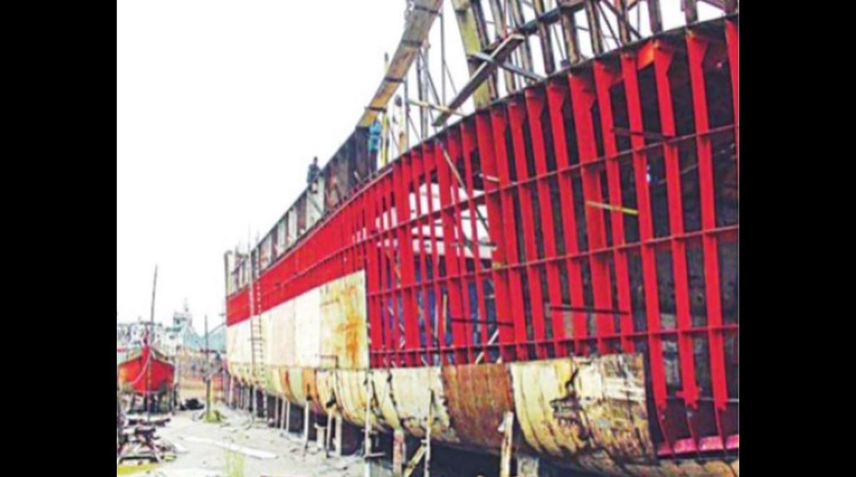
A thriving shipbuilding industry had also existed and flourished since ancient times in Bengal. The Moroccan scholar and traveller Ibn Batuta wrote about his visit to Bengal in the 14th century where he “saw numerous boats in the river carrying men and merchandise and testified to the existence of gigantic fleet of warboats.” Chittagong was reputedly the centre of building ocean-going vessels. In the 17th century, the shipbuilding institutions of Chittagong are reported to have built a complete fleet of war-boats for the Sultan of Turkey.
During the Mughal period, Bengal is said to have taken the lead in building ships and boats. The Mughal naval force had many ships built at Chittagong. The British Navy also used warships built at Chittagong, at least one of which reportedly comprised Nelson’s victorious fleet in the famous Battle of Trafalgar in 1805. During the first half of the 19th century, the shipyards at Chittagong built ships up to 1,000 DWT.
If trade and connectivity are handmaidens to each other with the latter actively promoting the exchange of ideas, goods and services, it follows axiomatically that disruption to this connectivity will translate into disruption of trade and people-to-people exchanges with deleterious consequences for all. After 1947, but most noxiously after the India-Pakistan war of 1965, land, rail and riverine connectivity was almost totally severed and remained hostage to negative politics of the Partition Syndrome until very recently.
The first concrete and, for this sub-region, revolutionary breakthrough occurred when the BBIN (Bangladesh-Bhutan-India-Nepal) sub-regional grouping, in early 2015, signed the BBIN-MVA. This seminally important document symbolises the beginning of the revival of the historic connectivity corridors that had existed prior to 1947, albeit only partially.
The best, most efficient and most optimum way forward in restoring connectivity is to adopt an organic approach. The BBIN sub-region (which could be likened today to being the rump core of the pre-Partition Bengal Presidency of British India) should consider reviving the connectivity in this sub-region, which conforms best to the geomorphology of the terrain.
Road, rail and riverine connectivity is best understood if analogously compared with the human body’s superbly efficient circulatory system. The arteries, veins and capillaries have their own respective clearly defined function.
The British colonial rulers had fully understood this. In the larger alluvial plains and region, dominated as they are by the waters of the mighty eastern Himalayan rivers, and where even the hills are essentially soft alluvial foothills of the higher Himalayan range, trying to build highways conforming to international transportation standards and maintaining them round-the-year have always posed a gigantic challenge. The monsoonal climate and geomorphology of terrain militated against these roads.
Understanding such challenges well, the British put in place a superb organic system of communications, synergising the advantages offered by the rivers as primary arterial waterways, and augmenting their carrying capacity by building an efficient railway network linking with junctions that became hubs at major river points; while the roads comprised the capillaries that transported goods, services, peoples and ideas to and from the farthest nooks and crannies of the land to these river and railway hubs. The efficient use of such a synergised and organically meshed communication system is what made the Bengal Presidency the richest in British India. In terms of fuel economy and carbon emission, river transportation is most economically efficient and environment- friendly.
Tragically, following the 1965 war between India and Pakistan, the extensive river connectivity that had inseparably linked the peoples and lands of the erstwhile Bengal Presidency, now BBIN sub-region, was grievously disrupted. The abrupt severance of the water links that had inextricably and symbiotically bound them together transformed the Northeastern Indian states, as well as Bhutan, Nepal and Sikkim, from having been integrally and historically water-linked and economically prosperous, into becoming landlocked and impoverished. With shipping services being stopped, the flourishing river economy that had made this part of the subcontinent so famously prosperous wilted away, with upstream and downstream industries disappearing.
This sub-region can best, and most efficiently, revive its old prosperity by reconnecting through their shared waterways that still connect them, inextricably and inescapably, political differences notwithstanding. Reviving the rivers, for connectivity as well as for restoring the river economy, must necessarily involve engaging proactively with the people who inhabit the countless villages, towns and cities that dot both banks of each of these rivers, and restore to them a sense of ownership and pride in their shared commons.
Regional connectivity, now under process of resuscitation within the BBIN sub-region, could well serve as the operationalising pathway to larger trans-regional connectivity, between South Asia and Southeast and East Asia.
I envision the fledgling, still fragile, BBIN process eventually giving heft to the somnolent Bay of Bengal Initiative for Multi-Sectoral Technical and Economic Cooperation, invigorating a still nascent Bay of Bengal community linked together symbiotically by the Bay that laps their shores. We could conceivably envision this sub-region, and beyond to the east, once more reclaiming its great reputation of prosperity that it had enjoyed as the Bengal Presidency, this time not for enriching the coffers of any foreign power but for the shared and greater prosperity of the peoples who are inhabitants of the region now. Without in any way surrendering their recently defined sovereign, independent national status, these entities would do well to reintegrate economically, ecologically and environmentally, for the greater and collective good of their respective peoples.
The writer is a former career diplomat and currently a visiting fellow at BRAC University, Dhaka.
The daily star/ann