The Sarasvati Civilization
The recent decision of the Government of Haryana to promote tourism at the archaeological site of Rakhigarhi (Hisar) by encouraging homestays.
The great civilisations and urban centres of the world have all risen on the banks of rivers. This is evidently…

The great civilisations and urban centres of the world have all risen on the banks of rivers. This is evidently because river valleys are well watered and fertile, apart from the facility of transport and communication. The discovery of urban remains at Mohenjo Daro and Harappa was evidence of sophisticated civilisation, 4,600 to 3,900 years ago, of the same antiquity as those of Egypt and Mesopotamia, clearly nourished by the river Indus.
A good many sites belonging to the same ancient urban civilisation, however, have been discovered within the belt between the Indus system of rivers to the west of the Indian subcontinent and the Gangetic plain, to the east — a region that is not served by a river system. This contradiction appeared to have got resolved with the discovery of a now-defunct river bed, the Ghaggar-Hakra ancient river channel, along the line of the urban civilisation sites. The discovery suggested that there was a Himalayan river that flowed through this channel and supported these settlements, which were abandoned when the river dried up or changed course.
Advertisement
Work by Philippa J Mason, Alexander L Densmore, Andrew S Murray, Mayank Jain, Debajyoti Paul and Sanjeev Gupta, of Imperial College and University of London, Technical University and Aarhus University of Denmark, Universities at Glasgow, St Andrews and Durham, UK and Indian Institute of Technology, Kanpur, India, however, reveals that the river that flowed along the Haggar-Hakra channel moved away long before the Bronze-Age civilisation that prospered in the region. The study, published in the journal, Nature Communications, finds that it was the relict, underfilled topography of an abandoned valley of the Himalayan Sutlej River, rather than an active Himalayan river, where several ancient urban centres grew. This suggests that the stability of a region from which a river had migrated, rather than the unpredictable course of an active Himalayan stream, could also support productive human settlement.
Advertisement
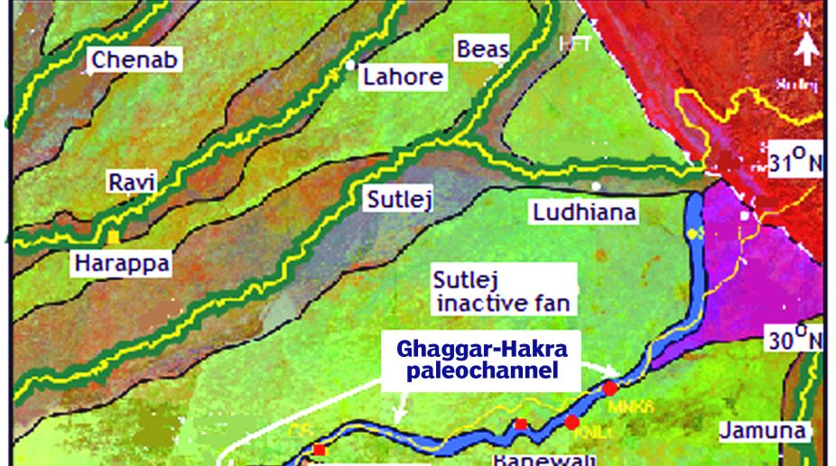
The map of the Indo-Gangetic plain shows the system of the Indus and its tributaries on the west and the Jamuna and the Ganga to the east, with a less watered region, including the Thar Desert, in between. While the sites of Mohenjo Daro and Harappa are along the course of the Indus, those of Kalibangan, Banawali, Bhirana and Kunal and a host of others are away from Himalayan rivers. Late in the 19th century, the Nature Communications paper says, traces of an ancient, defunct river bed that swept through this region were discovered. Surveys in the region have also uncovered ruins of several urban-scale settlements, associated with this river-bed trace and dated to the same period as the Indus valley civilisation. Further study identified this trace as the course of an ancient river that flowed from the Himalayas in Himachal Pradesh, down through Rajasthan and through to Pakistan.
The ancient channel has been considered as the path of a Himalayan river that once supported Indus Valley period settlements, including the important ones of Kalibangan and others. The ancient river has also been linked with the mythical Saraswati river, which has been mentioned in the Vedas and is believed to join the Jamuna and the Ganga at their confluence through an underground passage. The channel, however, is now only a flow of water during the rainy season, known as the Ghaggar, in India and the Hakra in the part that lies in Pakistan.
It has been believed that the drying up of the river that once flowed through the channel led to the decline of the settlements that the river supported and may have led to the collapse of the Indus urban system. While it has been suggested that the river dried up because sources were diverted owing to movements in the earth’s crust or climate change, there is no evidence of such events and there have been no detailed studies to establish the role of rivers in the rise and fall of urban centres in this region, the paper says.
The team of researchers hence undertook a study of the ancient channel by means of satellite imaging and then analyses of deposits recovered by “coring”, or drilling into the earth, and lifting out a column of accumulated and consolidated silting. The satellite survey consisted of mapping the radiation in the infra-red emitted by the Earth’s surface. The damp conditions along the ancient channel affect the extent of IR emission, which is different in drier regions, and the trace of the channel shows up in the IR emission map.
The picture shows two main swathes, called the “fan”, of deposits along regions which have fed the river over eons, the green areas in the picture. These areas, however, are now not related to the flow, which has consolidated its course. And then, there is a five to six km-wide channel, shown in blue, in the Sutlej fan, extending from where the Sutlej emerges from the Himalayas and till the Thar Desert. The satellite image suggests that the blue portion represents a cooler and less reflective surface, or sediment with greater moisture content. The researchers interpret this damp and sinuous feature to represent the trace of the Ghaggar-Hakra ancient drainage system.
Now to test the idea that the Ghaggar-Hakra channel was the relict of a Himalayan river and related to the decline of the Indus Valley urban settlement, the composition of the consolidated sediment was investigated along the channel at various depths. Five cores, going down to more than 40 metres, were drilled near the site of the urban settlement at Kalibangan in Rajasthan. The result of the operation was to obtain samples of sediments indicating the surface activity at various times in the past, extending to many thousands of years before the present.
It was found that the sediment at greater depths was of the kind that is dropped on the bed of Himalayan rivers, which indicated that a major river flow did exist over the Kalibangan area. The change in the character of the sediments, as one moved upwards, suggests, that the flow reduced from normal river flow till it was nearly stagnant and pond-like. To confirm whether the transition indicated cessation of river flow, and hence the decline of settlements, particularly of the Indus Valley epoch, the group estimated the age of the different core sections.
The method used is called Optically Stimulated Luminescence and works because certain minerals collect energy from cosmic radiation and then give up this energy in the form of radiation. The minerals in buried sediments, however, keep absorbing energy and do not radiate. Hence, they store energy, which they release by radiation, when exposed and illuminated by light of the appropriate colour. The nature and extent of the radiation, or luminescence, then indicates how long the sample has been storing cosmic radiation, and hence its age.
The result of the investigation was that while there was a river flowing over these areas in ancient times, the flow stopped well before the Bronze Age settlements of the Indus Valley were at their zenith. And there was evidence that it was the Sutlej that followed a course more to the east, till it changed course, well before the Indus Valley period, and settled into its present, stable river valley.
The flourishing urban settlements in the region hence arose not adjacent to an active Himalayan river but in the comparative stability of the abandoned valley. Himalayan rivers tend to frequently change course, often coming back to the course they followed earlier. The Sutlej, after it moved to its present path, some eight thousand years ago, has stayed trapped in an “incised” valley. The stability this gave to the Ghaggar-Hakra region was the environment for productive social evolution that marks the Indus Valley civilisation, the Nature Communications, paper says.
(writer can be contacted at response@simplescience.in)
Advertisement