The Ring of Fire, also known as Circum-Pacific Belt or Pacific Ring of Fire, is the place where most earthquakes occur. This ring is said to be dotted with 75% of Earth’s all active volcanoes.
The Ring of Fire, however, is not exactly round. It’s a long horseshoe-shaped belt of seismic activity around the edges of the Pacific Ocean.
Advertisement
The ring stretching nearly 25,000 miles apparently includes more than 450 volcanoes. According to seismologists, this belt stretches from the southern tip of South America, along the North America coast, across the Bering Strait, down through Japan, and into New Zealand.
Most earthquakes, and approximately 75 per cent of all volcanoes, occur within this Ring of Fire caused by plate tectonics — huge slabs of the Earth’s crust. These slabs move constantly above the solid and molten rock layer below the Earth’s crust. When the oceanic plates slid under continental plates, the Ring of Fire was formed.
READ | This is how you can help Indonesia earthquake victims
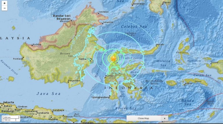
Sitting on this Ring of Fire, Indonesia happens to be one of the most disaster-prone countries in the world. A 7.4-magnitude earthquake and subsequent tsunami struck Central Sulawesi in Indonesia on 28 September Friday causing widespread loss of life and property.
Before Central Sulawesi was hit, Indonesia suffered at least eight earthquakes in 2018 — and five of them were of above 6 magnitude on the Richter scale. The 2017 earthquake map shows that the number of active faults across Indonesia has increased from 81 in 2010 to 295.
According to the Center of Volcanology and Geological Hazard Mitigation, Indonesia, the deteriorating Palu-Koro fault had amplified the jolt of the 7.4-magnitude earthquake that hit Donggala regency in Central Sulawesi on 28 September.
The fault — a fracture in the earth’s crust — runs from the Makassar Strait to the northern part of Boni Gulf in southern Sulawesi underneath Sulawesi Island. What is believed to have triggered Friday’s major earthquake is a shift of this fault.
WATCH | Video of tsunami hitting Palu
“The geological map of Central Sulawesi is composed of rocks that are aged between 10,000 and 1 million years. But it fell into decay, causing the jolts to be stronger,” The Jakarta Post quotes Sri Hidayati, head of the institution’s earthquake mitigation, as saying.
Sri was involved in compiling the 2017 Indonesia Earthquake Map. According to him, it was an active fault with a motion ranging between 30 and 44 mm per year.
The death toll in the 28 September earthquake in Palu and Donggala has crossed 800. Over 500 people are injured and more than 15,000 people have been reportedly displaced and sheltered in relief camps.
The Central Sulawesi administration has declared a 14-day state of emergency up to October 11.
(With inputs from The Jakarta Post/ANN)