Bird walk at Durgapur barrage highlights ecological concerns
Established in 2015 to commemorate the global Great Backyard Bird Count (GBBC), the initiative has spent over a decade documenting the avian diversity of this critical riverine landscape.
By Tuesday evening, it is likely to move west-northwestwards and weaken into a well-marked LPA and finally emerge into the northeast Arabian Sea near Gujarat coast on 30 September, where-the IMD said-there is likelihood for the system to further intensity over northeast Arabian Sea during subsequent 24 hours

IANS
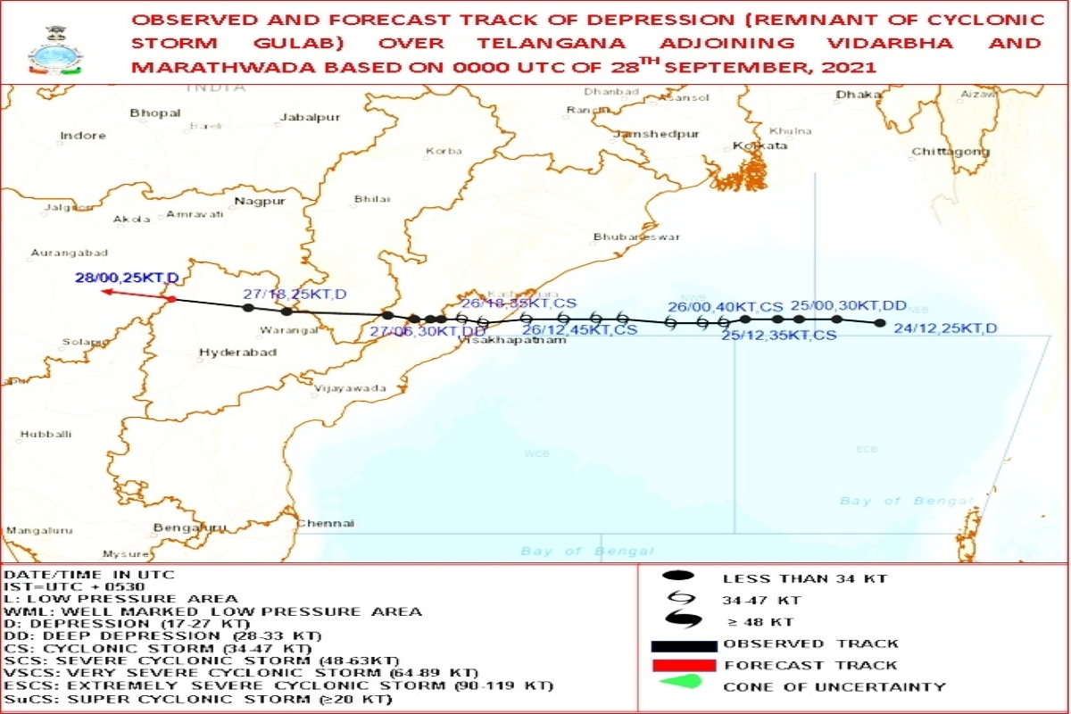
It started as a ‘Low Pressure Area’ (LPA) over east-central Bay of Bengal on September 24; by September 25 noon, it had turned into a well-marked LPA over east-central Bay of Bengal and by night, the India Meteorological Department (IMD) had issued a pre-cyclone watch alert for north Andhra Pradesh and adjoining south Odisha.
It intensified into a Cyclonic Storm by Saturday, which would cross over south Odisha – north Andhra Pradesh coast on Sunday evening.
Advertisement
As the Cyclonic Storm ‘Gulab’ made landfall over the identified coastal area, the system maintained its cyclonic storm intensity and weakened into a deep depression only in the early hours on Monday and continued its westward march.
Advertisement
The deep depression, the same remnant of Cyclone Gulab, weakened into a Depression over north Telangana and adjoining south Chhattisgarh and Vidarbha by Monday evening.
By Tuesday evening, it is likely to move west-northwestwards and weaken into a well-marked LPA and finally emerge into the northeast Arabian Sea near Gujarat coast on September 30, where – the IMD said – there is likelihood for the system to further intensity over northeast Arabian Sea during subsequent 24 hours.
The situation where a single system in the Northern Indian Ocean can create two cyclones is not unprecedented.
The IMD records show that the Very Severe Cyclonic Storm (VSCS) Gaja in November 2018 over the Bay of Bengal had crossed over Tamil Nadu coast as VSCS on November 15, 2018; weakened into a Depression over land and re-emerged as a Depression over South-East Arabian Sea on November 16, 2018 and then re-intensified into a Deep Depression over Arabian Sea on November 17, 2018 to become a well-marked LPA (WML) over the south-eastern Arabian Sea on November 19 that year.
“In case of re-intensification of the remnant, a new name is given to the system, IMD said.
While it is not rare to have cyclones or cyclonic storms in September – India has two seasons for cyclones, pre-monsoon (March to May) and post-monsoon (October to December) – it is not even that common, the scientist said.
Meanwhile, another cyclonic circulation in the Bay of Bengal off Myanmar coast has appeared.
“It is the remnant of a tropical storm over the Pacific (that has) emerged into the Bay of Bengal, in the form of a cyclonic circulation. It is a much weaker system as compared to a depression,” explained an India Meteorological Department (IMD) scientist.
Advertisement