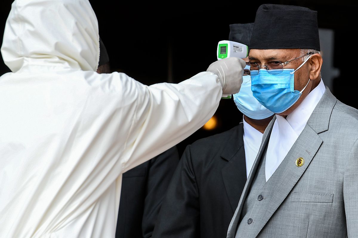
In a latest shocker amid row over a “new map” claiming parts of Indian territory, Nepal Prime Minister KP Oli has said that “Indian virus looks more lethal than Chinese and Italian now”.
In a speech in parliament, Oli has blamed India for the spread of Coronavirus cases in his country.
Advertisement
“Those who are coming from India through illegal channels are spreading the virus in the country and some local representatives and party leaders are responsible for bringing in people from India without proper testing,” the Nepal PM was quoted as saying by NDTV.
“It has become very difficult to contain COVID-19 due to the flow of people from outside. Indian virus looks more lethal than Chinese and Italian now. More are getting infected,” he further said outraging officials in India.
The offensive comes as India and Nepal are engulfed in a diplomatic war over a disputed border area.
Earlier in the parliament, KP Oli had reiterated Nepal’s claim to Limpiyadhura, Lipulekh, and Kalapanias after the government showed the ‘disputed’ territories in a newly issued political map.
He said that diplomatic efforts will be made to “bring back” the territories.
“As Prime Minister of the incumbent government, I want to appraise the honourable house that the issue of Limpiyadhura, Lipulekh, and Kalapani won’t be covered up, a conclusion will be drawn regarding it. We won’t let this issue fade out and it will be sorted out through diplomatic talks making concrete efforts and the territories will be reclaimed,” he said.
Nepal’s Cabinet had on Tuesday endorsed a new political map showing Lipulekh, Kalapani and Limpiyadhura under its territory, amidst a border dispute with India.
The move announced by Foreign Minister Pradeep Kumar Gyawali came weeks after he said that efforts were on to resolve the border issue with India through diplomatic initiatives.
The Lipulekh pass is a far western point near Kalapani, a disputed border area between Nepal and India. Both India and Nepal claim Kalapani as an integral part of their territory – India as part of Uttarakhand’s Pithoragarh district and Nepal as part of Dharchula district.
Gyawali said that the official map of Nepal will soon be made public by the Ministry of Land Management.
Decision of the Council of Ministers to publish the map of Nepal in 7 provinces, 77 districts and 753 local level administrative divisions including Limpiyadhura, Lipulekh and Kalapani, he wrote on Twitter on Monday.
Gyawali last week summoned the Indian Ambassador Vinay Mohan Kwatra and handed over a diplomatic note to him to protest against the construction of a key road connecting the Lipulekh pass with Dharchula in Uttarakhand.
India has said that the recently-inaugurated road section in Pithoragarh district in Uttarakhand lies completely within its territory.
The Nepalese government has said that it will soon publicise the new political map that incorporates the territories unilaterally kept by India on its side of the border.
However, senior Nepal Communist Party and member of Nepal Communist Party Standing Committee Ganesh Shah said the new move may escalate unnecessary tension between Nepal and India at a time when the country is fighting the coronavirus.
The new map includes 335-km land area including Limpiyadhura in the Nepalese territory.
The new map was drawn on the basis of the Sugauli Treaty of 1816 signed between Nepal and then the British India government and other relevant documents, which suggests Limpiyadhura, from where the Kali river originated, is Nepal’s border with India, The Kathmandu Post quoted an official at the Ministry of Land Reform and Management as saying.
President Bidhya Bhandari, addressing Parliament last week, reiterated that Limpiyadhura, Kalapani and Lipulekh belong to Nepal and appropriate diplomatic measures will be adopted to resolve the existing issues with India.
India had in November, last year, released a political map showing Kalapani within Indian borders. The map was released after the creation of the new Union Territories of Jammu and Kashmir and Ladakh.
The Indian map places the Kalapani area under the Pithoragarh district in Uttarakhand whereas Kathmandu considers the unresolved area to be part of Nepal’s Darchula district.
Following Nepal’s objection, India had said that the country’s map “accurately depicts the sovereign territory of India”.
Then Ministry of External Affairs spokesperson Raveesh Kumar had stated that the “new map has in no manner revised India’s boundary with Nepal”.
The tension further escalated after India inaugurated a road link connecting Kailash Mansarovar, a holy pilgrimage site situated at Tibet, China, that passes through the territory belonging to Nepal.
The 80 km new road inaugurated by Defence Minister Rajnath Singh earlier this month is expected to help pilgrims visiting Kailash-Mansarovar in Tibet in China as it is around 90 kms from the Lipulekh pass. “The road follows the pre-existing route used by the pilgrims of the Kailash Mansarovar Yatra,” spokesperson of the Ministry of External Affairs Anurag Srivastava said in New Delhi recently.