A powerful earthquake struck off the southern Philippines on Monday morning, killing at least 15 people, prompting tsunami warnings across parts of the country and triggering alerts in neighbouring nations as authorities rushed to assess the scale of damage.
The offshore earthquake measured 7.8 in magnitude and struck near Mindanao Island at 7:37 am local time, according to the Philippine Institute of Volcanology and Seismology. The earthquake triggered tsunami warnings and evacuation orders across parts of the region, with alerts issued in the Philippines, Indonesia and other countries around the Pacific.
Advertisement
The epicentre was located about 32 km southwest of Maasim town in Sarangani province at a depth of 33 km.
The death toll from the earthquake has risen to 15, according to officials from the Philippine Office of Civil Defence cited by WAM. Civil Defence Office Director Rodrigo Sosmena said 12 of the fatalities were reported from Soccsksargen, a region comprising South Cotabato, Sultan Kudarat, Sarangani and General Santos City. At least 129 people were injured, he added.
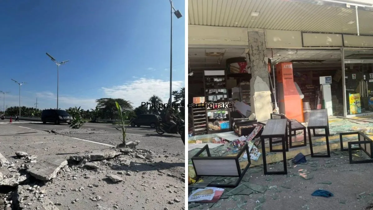
Authorities continued to assess damage and monitor affected communities across the region.
The Philippine Institute of Volcanology and Seismology said tsunami waves recorded in six areas in Mindanao reached as high as 1.4 metres. The agency maintained warnings for several coastal provinces and urged residents to stay away from shorelines until further notice.
Local media reported that some buildings collapsed and power outages were reported in parts of southern Mindanao.
Emergency response activated across the Philippines
Following the earthquake, Philippine authorities issued a tsunami warning covering nine coastal provinces, including Sarangani, Davao Occidental, Tawi-Tawi and Sulu, and urged residents in vulnerable areas to immediately move to higher ground or farther inland.
Philippine President Ferdinand Marcos Jr said emergency response agencies had been activated, including the Office of Civil Defence and the National Disaster Risk Reduction and Management Council. He also urged residents in vulnerable coastal areas to move to higher ground and follow evacuation advisories issued by local authorities.
The Department of Social Welfare and Development (DSWD) said it had begun coordinating with local government units across Mindanao. According to the Philippine News Agency, Social Welfare Secretary Rex Gatchalian said more than 1.1 million family food packs were available in Mindanao for immediate distribution to affected families.
The DSWD’s Disaster Response Management Group also reported that around 4.7 million family food packs had been prepositioned nationwide for emergency deployment. Quick Response Teams have been placed on standby and are coordinating with local authorities for possible resource augmentation.
“DSWD is more than ready to provide immediate response by supporting the needs of the affected families in the entire Mindanao,” Gatchalian said, adding that field offices had been directed to coordinate closely with local governments and deploy social workers to evacuation centres.
He also instructed concerned field offices to deploy mobile command centres, mobile kitchens and other emergency resources where required.
The Philippine National Police said it remained on alert and was coordinating with relevant agencies as rescue, evacuation and relief operations continued.
Indonesia lifts tsunami warning
Indonesia’s Meteorology, Climatology and Geophysics Agency (BMKG) issued a tsunami warning for coastal areas in the country’s northeast following the quake. However, the agency later lifted the warning after observations showed sea levels had returned to normal.
BMKG said minor tsunami waves had been detected at several coastal monitoring stations in northern Indonesia earlier in the day. The earthquake also triggered panic in some coastal communities, though there were no immediate reports of casualties in the country.
Evacuation advisories were issued in parts of Indonesia’s North Sulawesi, North Gorontalo and the Sangihe Islands.
Officials in Japan also issued alerts warning of hazardous waves and urged residents in vulnerable coastal areas to move to safety. The US-based Pacific Tsunami Warning Center had earlier warned that tsunami waves of up to three metres could affect parts of the Philippines, while waves of up to one metre were possible in parts of Indonesia and Malaysia.
NCS records two strong tremors
Meanwhile, India’s National Centre for Seismology (NCS), in a post on X, said a magnitude 7.7 earthquake struck at 5:07 am IST at a depth of 93 km.
“EQ of M: 7.7, On: 08/06/2026 05:07:45 IST, Lat: 5.635 N, Long: 125.147 E, Depth: 93 Km, Location: Philippines,” the agency said.
A second strong tremor followed minutes later. The NCS reported a magnitude 6.4 earthquake at 5:18 am IST, occurring at a depth of 79 km.
“EQ of M: 6.4, On: 08/06/2026 05:18:10 IST, Lat: 5.605 N, Long: 125.408 E, Depth: 79 Km, Location: Philippines,” the NCS added.
Seismic activity is a recurring feature of life in the Philippines, which sits atop the Pacific Ring of Fire, one of the world’s most active earthquake zones.