With the first heavy monsoon showers of the season hitting the country’s northwest things are already getting bad for Himachal Pradesh, Uttarakhand and parts of Haryana.
This past weekend, HP experienced incessant rain in many of the state’s districts that brought in its wake cloudburst, landslides, flash floods, and other weather-related catastrophes that have already claimed two lives in the state.
Advertisement
What are flash floods?
Flooding can occur as a result of water becoming stagnant when it rains excessively or continuously for several days or during a specific season. Such a condition is referred to as a “flash flood,” which happens quickly and is quite localised. For instance, according to the National Weather Service, a meteorological service in the US, flash floods can happen shortly after heavy rain or an abrupt release of water trapped by ice.
They have the power to roll rocks, chop down trees, raze structures like buildings and bridges, and scour out brand-new channels. Rapidly rising water can rise 30 feet or more in height. Furthermore, rainfall that causes flash floods can also result in disastrous mud slides. These devastating, unexpected floods won’t always give you a warning.
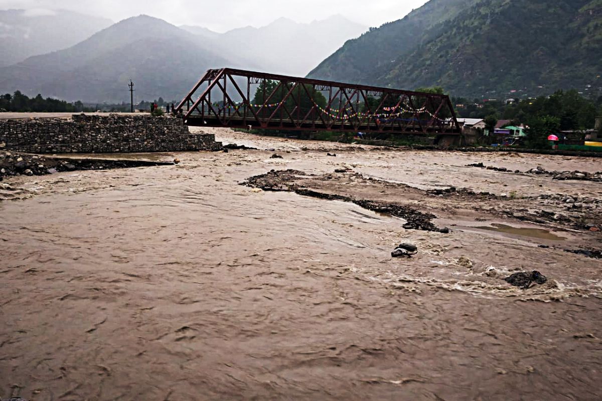
Numerous rivers in the area, particularly the Beas, were in spate as a result of the intense rain. Authorities opened the Pandoh dam’s floodgates as a preventative measure to let water from the overflowing river flow out.
The heavy monsoon rains has already made its impact, though. More than a dozen vehicles were washed away in the state’s flash floods in addition to many stretches of roadways becoming waterlogged. In the rainy destruction, many buildings, including homes, suffered catastrophic damage. 124 highways in Himachal were closed as a result of landslides and waterlogging, according to the State Disaster Management Authority. The Chandigarh-Manali and Bajaura-Kautala routes were where this was most clearly seen.
Additionally, in the Mandi neighbourhood near the Baggi bridge, about 200 people are still stranded. Massive landslide-related obstructions caused a 15-km-long backup on the Mandi-Kullu highway. Trapped people which mainly include tourists are being relocated to safer regions while efforts are being made to clean the debris, passengers are also left trapped in Khotinallah near Aut (in HP) on the Pandoh-Kullu road. Health professionals and state disaster response teams are on high alert to handle any problems. Residents beside waterways are urged to exercise additional caution, as rivers like the Ganga are still flowing at high levels.
Uttarakhand, where two further people died in separate rain- and landslide-related incidents, is in no better shape. The India Meteorological Department (IMD) reports that Haridwar saw a record-breaking 78 mm of rainfall in the 24-hour period.
Various areas of the Kangra, Mandi, and Sirmaur districts have seen heavy rains. There was a 15-km-long traffic delay on the Mandi-Kullu route due to a significant number of landside-related obstructions. Debris removal efforts are under progress, and the stranded—mostly tourists—are being relocated to safer regions. Authorities have also stopped the Kedarnath pilgrimage in Sonprayag in the Rudraprayag district because of surrounding danger. Pilgrims have been encouraged to continue only after taking the necessary measures and weather updates.
The majority of the area is expected to experience mild to moderate showers in some capacity until Friday. In some areas, at this time, extremely significant chances of both thundershowers with lots of lightning and heavy rain at approx. 115.5 mm exists. As a result, IMD has upgraded both states to a yellow watch for June 29 & 30 and reduced both to an orange alert to be prepared against the hazardous weather.