Fraudsters allegedly sell government ‘Mountain’ land in Prayagraj; FIR filed Against 19
Residents of Prayagraj may have seen Bollywood films in which fraudsters sell iconic government buildings or even the Taj Mahal.
Scientists have identified a 200 km-long buried ancient river, approximately 4 km wide and 15–25 meters thick.

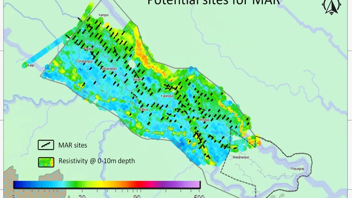
Photo: SNS
Under the National Mission for Clean Ganga (Namami Gange), the aquifer mapping project in Prayagraj focuses on Ganga River rejuvenation by enhancing its natural flow through sustainable groundwater recharge and regulation. The project incorporates innovation and advanced technological approaches, including smart water management systems, remote sensing, and drone technology, officials have disclosed on Monday.
This system will not only enhance water supply but also help maintain the natural flow of rivers. In addition, the implementation of technological methods for conserving water sources and addressing regional water scarcity will ensure a stable water supply in the future.
Officials said as part of the Namami Gange Mission, a significant discovery has been made during aquifer mapping focused on paleo-channels in the Ganga-Yamuna doab region between Prayagraj and Kanpur. Scientists have identified a 200 km-long buried ancient river, approximately 4 km wide and 15–25 meters thick. This discovery has added a new chapter to Indian history and culture. The project used cutting-edge technologies such as satellite imaging and geospatial data to map the old river routes and subsurface reservoirs.
Advertisement
Aquifer studies reveal that this ancient river holds a water storage potential of nearly 3,500–4,000 million cubic meters (MCM). Over 150 Managed Aquifer Recharge (MAR) sites have been identified, where recharge structures will be built to increase groundwater levels and sustain river baseflow. In the first phase, 20–25 MAR sites will be developed, with Council of Scientific & Industrial Research, National Geophysical Research Institute (CSIR–NGRI) installing automatic water-level indicators for scientific monitoring. A proposed MAR structure of 5 m × 5 m × 3 m will ensure effective recharge. The project is being carried out in collaboration with the Uttar Pradesh State Groundwater and Irrigation Department, marking a decisive step in aquifer rejuvenation.
Advertisement
The successful implementation of the aquifer mapping project in Prayagraj will enhance groundwater recharge and improve river flow, supporting NMCG’s vision of Aviral Ganga. Latest technologies have been employed for infrastructural development, leading to improved methods of enhancing river flow and groundwater recharge. Through subsurface reservoir systems, permanent and technological solutions are being provided to address the issue of water scarcity in the coming years.
The research and technology-driven initiatives under the Namami Gange Mission are playing a crucial role in restoring river ecosystems. These efforts include subsurface reservoir management, advanced remote sensing, GIS-based databases, and infrastructural solutions, which will help re-establish river ecosystems while ensuring sustainable measures for water conservation.
These initiatives will not only reduce the impacts of climate change and water scarcity but also take concrete steps toward preserving the Ganga and other rivers for future generations.
Innovative initiatives like the aquifer mapping project in Prayagraj under the Namami Gange Mission are not only crucial for conserving the Ganga River. Still, they are also showing a strong direction for tackling water crises across the country. With state-of-the-art technological solutions and scientific approaches, significant steps are being taken toward restoring river ecosystems. These initiatives enable the combat of climate change impacts, ensure effective water resource management, and implement robust measures to increase the flow in the River Ganga.
Advertisement