CM Yogi gives children the message of self-discipline and hard work through Japan’s example
Uttar Pradesh Chief Minister Yogi Adityanath gave students the mantra of self-discipline and hard work by citing the example of Japan.
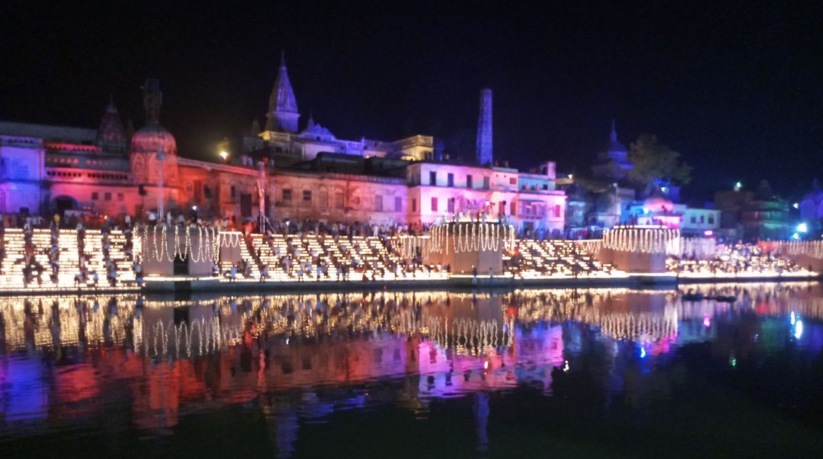
Ayodhya is located 7 km away from Faizabad city, which is governed by and is the headquarters of the Ayodhya Municipal Corporation or Ayodhya Nagar Nigam.

(Photo: Twitter/@PIB_India)
The Faizabad district of Uttar Pradesh will now be known as Ayodhya. Chief Minister Yogi Adityanath made the announcement in his Diwali speech on Tuesday. The Faizabad name change comes less than a month after another major UP city Allahabad was renamed as Prayagraj. While UP already has a city called Ayodhya, which is a little distance away from Faizabad city and shares its municipal limits with the latter, the district of Faizabad will also be known as Ayodhya from now.
Ayodhya-Faizabad distance and municipal limits
Advertisement
Ayodhya is located 7 km away from Faizabad city, which is governed by and is the headquarters of the Ayodhya Municipal Corporation or Ayodhya Nagar Nigam.
Advertisement
Ayodhya was earlier part of the Faizabad Nagar Nigam. In 1978, the temple town was separated from Faizabad Nagar Nigam and the Ayodhya Nagar Nigam came into being. Later, it became Nagar Nigam Parishad Ayodhya.
Read More: Yogi Adityanath renames Faizabad to Ayodhya
In May 2017, the Uttar Pradesh government once again merged it with the Faizabad Nagar Nigam, after which the entire functioning of Ayodhya and Faizabad municipalities came under the Ayodhya Nagar Nigam.
Ayodhya and Faizabad history
While some believe that Faizabad is the name Muslim rulers gave to Ayodhya, the truth is otherwise.
While Ayodhya is an ancient city, also known as Saket, and finds mention in numerous Hindu mythological texts, Faizabad was founded as a separate city in 18th century by Nawab Saadat Ali Khan. The exact date of the founding of Faizabad is cited as 1722 AD. Saadat Ali Khan is believed to have constructed a fort and cantonment along the bank of the Gaghra river, laying the foundations of Faizabad.
On the other hand, Ayodhya has been mentioned in Ramayana, the Mahabharata and Vedic books. In the Buddhist texts written after the ancient Indian epics, the same place is called Saket. The name Ayodhya again finds mention in later Hindu texts such as Ramcharitmanas of Goswami Tulasidas. All, however, agree to one thing: that it was the capital of the Ikshvaku kings, the dynasty to which Ram belonged.
From the 13th century onwards, the city remained an important place under the Delhi Sultanate and later was the provincial capital of Awadh. In 1528-29, Mughal emperor Babur ordered the construction of a mosque in the city which was known as Babri Masjid.
Today, both Faizabad and Ayodhya can be seen next to each other in contemporary maps, but Rennel-Dury wall map of Delhi, Agra and Oudh from 1777 shows ‘Fyzabad’, as it is written, encompassing an area identified today as Ayodhya. In fact, the map, which is detailed enough to show every single city, town and village on a scale of 500 metres, does not show Ayodhya at all.
The map was made only 55 years after Saadat Ali Khan laid the foundation of Faizabad. By this time, Faizabad, the capital city of Awadh, had become a major city thanks to works of Nawab Shuja-ud-Daula, the third Nawab. The city remained prominent till the fourth Nawab of Awadh, Asaf-ud-Daula, shifted the capital to Lucknow in 1775.
A map of United Provinces (now Uttar Pradesh) from 1903, when India was under the British Raj, shows Ajodhia (Ayodhya) where it currently is. Faizabad, spelt exactly as it is today, is shown to the immediate southwest of Ayodhya. It is possible that an expanding Faizabad of the Nawabs had overshadowed Ayodhya’s importance to cartographers. But ever since the British rule, Ayodhya has remained an important geographic site largely due to its tremendous religious significance for the Hindus.
Advertisement