Heavy rain likely to pound Odisha, district collectors put on alert
The system is likely to move in a north-easterly direction along the Odisha coast, a CEC bulletin said.
Very heavy rainfall in coastal districts over the next two days may cause floods; Navy, Coast Guard and Army on alert; CM Naveen Patnaik reviews preparedness, asking officials to ensure timely evacuation of people from low-lying areas in the coastal belt

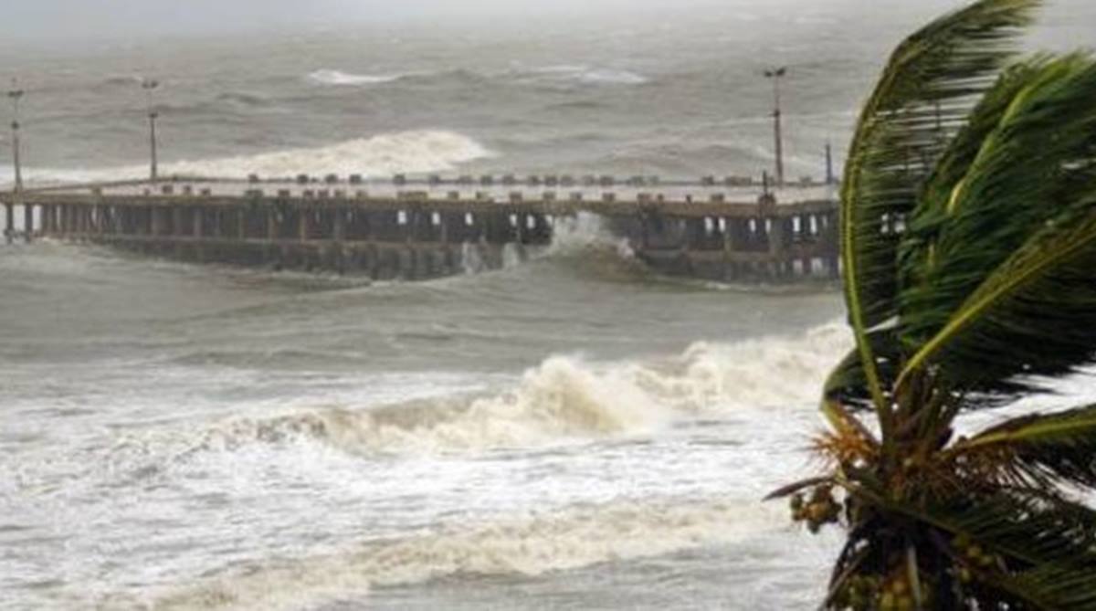
Tidal waves are likely to rise to 1 metre and inundate low-lying areas.. (Photo: PIB)
Coastal Odisha districts, particularly Ganjam, Gajapati, Puri, Kendrapara and Jagatsinghpur were put on red alert and evacuation of people from low-lying areas initiated as Cyclone Titli formed over the Bay of Bengal intensified into a very severe cyclonic storm and approached the Gopalpur-Kalingapatnam coast. The Cyclone Titli landfall is likely to take place at Gopalpur around 5.30 am on Thursday.
The India Meteorological Department sent out red messages with the forecast stating that the wind speed will touch 145 to 165 kmph. Tidal waves are likely to rise to 1 metre and inundate low-lying areas.
Advertisement
Very heavy rainfall in coastal Odisha districts over the next two days may cause floods, warned official sources. The Navy, Coast Guard and Army have been put on alert, though officials said their services had not been requisitioned yet.
Advertisement
Flights from Bhubaneswar have been cancelled. Train services on the southern section towards Vijayanagaram have been cancelled too.
READ | Cyclone Titli: Red Message issued for Odisha, north Andhra Pradesh
Cyclone Titli has a striking similarity to Phailin, the cyclonic storm that had hit Gopalpur on 13 October, 2013. This time, the cyclone has come two days earlier and the intensity is only marginally less as Phailin had a wind speed of over 200 kmph. The other aspects – landfall, districts to be affected ( 13), very heavy rainfall, floods and damages are predicted on similar lines.
The Odisha government had earned international accolades for successful handling of Phailin and evacuation of lakhs of people.
Chief Minister Naveen Patnaik reviewed the preparedness on Wednesday. He took stock of the situation, asking the collectors of Ganjam, Puri, Khurda, Kendrapara and Jagtsinghpur districts to evacuate people from low-lying areas in the coastal belt.
Chief Secretary AP Padhi said the district administrations of Ganjam, Jagatsinghpur, Kendrapara had already started evacuating people.
Padhi said immediate evacuation was being launched in view of the IMD forecast of a tidal surge of about 1m during the Cyclone Titli landfall.
The chief secretary said personnel from the National Disaster Response Force (NDRF) and the Orissa Disaster Rapid Action Force (ODRAF) had already been positioned in vulnerable districts.
“We have not yet sought help of Army. If required we may go for it,” Padhi said while replying a question.
The chief minister has asked the authorities to ensure “zero casualty” and keep cyclone shelters ready to house people affected by the natural calamity.
Patnaik has also ordered closure of all schools, colleges and anganwadi centres on Thursday and Friday in view of the IMD’s forecast of heavy to very heavy rainfall across the state. The college student union elections, earlier scheduled to be held on Thursday, have been put off.
The IMD said cyclone Titli moved at a speed of about 15 kmph during the last six hours over west-central Bay of Bengal and lay centred at about 180 km south-southeast of Gopalpur in Odisha.
After landfall, it is likely to re-curve northeastward, move towards Gangetic West Bengal across Odisha and weaken gradually, according to Director, Bhubaneswar Meteorological Centre, H R Biswas.
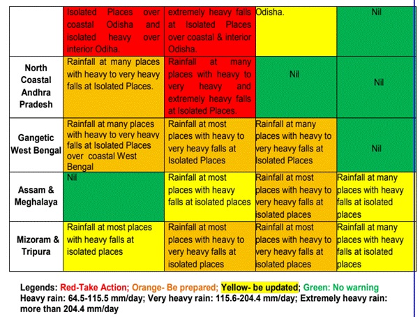
While several areas in coastal Odisha were lashed by rain on Wednesday, the IMD has forecast “heavy to very heavy rainfall” at several places and “extremely heavy rainfall” at isolated areas till Thursday under the impact of the very severe cyclonic storm.
The IMD said districts like Ganjam, Gajapati, Puri, Jagatsinghpur, Kendrapara, Khurda, Nayagarh, Cuttack, Jajpur, Bhadrak and Balasore were expected to receive heavy to very heavy rainfall till Thursday.
There is a forecast of heavy to very heavy rainfall for Kandhamal, Boudh and Dhenkanal districts also from Thursday.
The IMD said rainfall would be accompanied by gale wind speed reaching 140 to 150 kmph and gusting to 165 kmph along and off Odisha and north Andhra Pradesh coasts.
The sea condition is very high over west-central Bay of Bengal. “It is very likely to be phenomenal over the west-central and the adjoining north Bay of Bengal and along and off the south Odisha coast till Thursday,” said the IMD, adding that storm surge of height of about 1 metre above astronomical tide was very likely to inundate the low-lying areas of Ganjam, Khurda and Puri districts.
The IMD advised total suspension of fishing operations and shifting of coastal hutment dwellers to safe places. Fishermen along the Odisha coast, and central and north Bay of Bengal were advised not to venture into sea till Friday.
In view of adverse weather conditions, it has advised hoisting of local warning signal LW-4 at all ports of Odisha.
Special Relief Commissioner (SRC) B P Sethi said the Odisha government was prepared to face the possible floods in view of the heavy rainfall across the state.
Sethi said the state government had already informed the Indian Air Force and the Indian Navy about the situation and might take their help if required.
Around 300 motor boats have been arranged to assist in rescue operation as there is a likelihood of flood situation due to possibility of heavy rains till October 11.
#CycloneTitli. 08 #CoastGuard Ships including Interceptor Boats deployed by Eastern Seaboard have guided/shepherd more than 215 fishing boats to safety that were operating in Bay of Bengal.@IndiaCoastGuard Aircraft continue to scan sea for strayed boat if any @DefenceMinIndia pic.x.com/Iu1CmdTR0f
— Indian Coast Guard (@IndiaCoastGuard) October 10, 2018
All 836 cyclone and flood shelters have also been kept in a state of preparedness, while adequate relief materials arranged, he said.
(With PTI inputs)
Advertisement