The HMI went on a mountaineering expedition to Mt Kangyatse-I & II in Ladakh region during August this year. Kangyatse is the highest peak in Markha valley which is a popular trekking route. The expedition, led by me, consisted of 20 members which included two cooks and the curator of HMI. All members are HMI staff and climbing members are mountaineering instructors.
The expedition was conducted in alpine style and did not use any Sherpa/ HAP or guide above base camp. The team started on 1 August, travelled to Delhi by train, then to Leh by road via Manali. After a couple of days at Leh for acclimatisation, procurement and packing we left for road head at Chilling on 8th August. However, a cloud burst in Markha valley the previous day had caused mud slide and approach to Base Camp was blocked. We left Chilling on 10 August when we were convinced that the pack animals would not be able to cross it.
We had tied up with “Spiritual trek” run by Sub (Retd) Thundup- Namgyal to provide us with transport, pack animals and kitchen utensils. The ever efficient ex-serviceman JCO promptly sent us the vehicles before designated time to take us to Chogdoh. We found a nice camping ground inside a forested area near the road head. There was a small stream nearby and the sound of water was soothing to mind, body and soul. One has to pay charges for camping and horses to the local people and they give proper receipt. Chogdoh also has home stay options where particular houses are allowed to take in guests on particular days of the week.
Advertisement
On 11 August, we trekked to Nimaling (5019M) by crossing Kongmarula pass (5200M). On reaching, we were told by other trekkers that hardly any team reaches Nimaling from Chogdoh in a day. Approach to the pass was very steep and the day was extremely hot without a wisp of cloud or a little wind. It sapped us of the last ounce of energy to cross the pass.
However the view was overwhelming when we reached top of the pass. The Kangyatse Massif was standing tall to the south with all its glory and we could see the glaciers and streams absolutely clearly. Descent on southern side of the pass was gradual and after initial 200 mtrs or so it became almost flat. We reached Nimaling camping site where a trekking company has set up tents and other facilities for wandering trekkers. We set up our tents nearby and rested for the night on bank of the river originating from a glacier of Kangyatse massif.
Trek to Base camp from Nimaling took us only a couple of hours to complete. The route was across a ridge originating from Kangyatse and in NE-SW orientation.We pitched our tents at the traditional BC beside a stream which originates from the glacier on base of Kangyatse. The next day was spent taking rest and organising load for higher camps.
Already tied up with Indian Meteorological Department for weather forecast, we were receiving weather bulletin for next 48 hours daily and communicated with HMI on a satellite phone also.

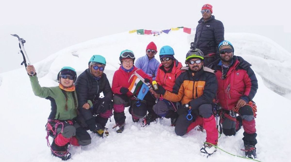
The team was divided into two groups for both the peaks. The plan was that we would establish high camps as near the summit as possible. This would ensure that we would have adequate reserve of energy after reaching respective summits. Thereafter both teams would try to traverse between the peaks and would descend down on the other side. Each team had nine members so that there would not be a problem of sleeping bags when one team got down the other side and would rest at the other team’s high camp for the night. The team composition was as follows:
Team1 comprised Wg Cdr Devidutta Panda, Nodup Bhutia, Tushar K Tapadar, Soumendu Mourdunya, Hav Pankaj Kumar, Umang Mukhia, Nima Lamu Lepcha, SulaxchanaTamang and Robin Gurung. Team 2 had Lakpa Sherpa, Roshan Ghatraj, Nk Deepak, Aditya Gurung, Powel Sharma, Pasang Tenzing Sherpa, Girish Gimnar, CN Das and Suraj Gurung.
We did a recce-cum-load ferry for Kangyatse-I on 14 August. Approach for the peak from the NE ridge which joins another ridge towards East. The point where these ridges join is the location of Camp-1. The lower Eastern ridge is filled with loose slate rock and scree. After reaching base of the northern ridge, we started climbing up clinging to the precarious slate stones. After labouring for about two and a half hours, we reached a slope with hard ice.
There was a rock wall at the end of the ice pitch and we had 3 options to negotiate it: climb straight up the rock wall/circumvent on the east side on loose slate stone and scree/circumvent on the west side on hard blue ice without any fixed rope. We decided to try the second option as it appeared to cost less energy. However it was easier said than done, we had to literally try out all kinds of rock climbing holds in the text book and haul ourselves up the slope. A final short pitch of rock climbing wearing climbing boots led us to the location of Camp-I. (33° 45’ 08” N 077° 33’ 47.6”E, Elev: 5908M).
We pitched one tent at the junction of the ridges where sufficient flat ground was available and dumped our entire load there. Another team of four sherpas and two German climbers had just reached the camp after a successful summit attempt.
We spoke to them about the route ahead. They confirmed that they would leave their fixed rope as it is. As ominous black clouds covered the whole sky and we could see signs of bad weather approaching, we made a hasty descent through the same route. We were back at Base Camp before evening and voraciously polished off an entire vat of chicken biryani which our cooks had prepared.
As per our original itinerary we would try to summit both peaks on Independence Day; however we got delayed in reaching BC itself due to the cloud burst. Trying to summit on 15 August would put the team under lot of pressure and would be risky as it would not allow sufficient time for rest, acclimatisation, load ferry & recce. Therefore postponed the plan and celebrated Independence Day at base camp by hoisting the Indian flag at the site of our prayer stupa where we had prayed the mountain gods for success of our expedition. I also tried to deliver a short speech in broken Nepali to the surprise and delight of the members.
On 16 August, as per plan we left BC for C-1 at 0800 hours as we were already aware of the route and had lesser load to carry. We reached the high camp at about 1300 hours; we could see Leh from this location and surprisingly were getting signal on our mobile phones. We had planned to start our summit attempt at 02.00 hours on 17 August; accordingly we organised our equipment and kept them ready. Had an early dinner and tried to get as much shut eye as possible before the assault. But I could not even blink my eyes out of excitement and worry.
Team-2 also left BC on 16 August at 1300 hours with load for high camp. They reached it, 300 metre above BC, after climbing for two hours on a ridge filled with slate stone and loose rocks. I had instructed the curator (CN Das) not to climb beyond high camp as Team- 2 would proceed for the planned traverse after summit. Having a member without any experience and knowledge of technical climb could put the entire team under grave risk during traverse. Another member (Nk Deepak) was showing symptoms of snow blindness, therefore he did not accompany the team beyond Base Camp. CN Das along with a kitchen helper went up to the high camp and returned to BC after dumping the load to help Team- 2.
It was 02.30 by the time Team-1 was ready for the summit attempt & radio contact was established with Team-2. Team-2 left for summit attempt about the same time. After climbing for one hour, they stepped on snow and wore crampons. The gentle slope and adequate snow did not necessitate use of fixed rope. Members climbed roped up on the ridge towards Kagyatse-II. Climbers attempting Kangyatse-II leave very early for summit attempt as snow gets soft with the heat which makes the climb and the subsequent descend very cumbersome.
Team-1 roped up and the climb appeared steep. The surface was hard blue ice and there was barely any snow. After about half-hour of climb, suddenly the gradient got much steeper and we could see the beginning of the fixed rope. The ropes had been fixed about 5 days earlier and we were not sure whether the tubular pitons were still in place. Therefore Nodup went ahead roped up while Umang gave him belay.
He checked the rope and tightened the tubular pitons. Then the rest of the team jumared till the end of the rope. We had to repeat this procedure many times. Route to the summit consisted of a series of ice walls and slabs. The entire summit pyramid seemed to consist of pure hard ice and nothing else. In the absence of snow, it was too tiring to climb the steep slope with front points. The wall was so hard that many a times the crampon points would simply rebound after hitting it.
In all there were about 7 steep long pitches to be climbed and no gentle slope even to rest our tired limbs for a moment and to pull out the thermos flask for a cup of warm water.
Its only when the day broke, that we realised the actual magnitude of the climb. One had to look 90° up to be able to climb as the slope was always steeper than 75°. The weather was marginal, sky was completely overcast and there was a gentle wind. Continual negotiation of the tough pitches finally brought us to summit ridge at 0930hours. There are three peaks on the summit ridge, each about 10m high.
The entire area was filled with crevasses and cornices. As per our observation the middle peak was a metre or two higher than the others but had hanging glaciers and was heavily corniced. We decided to put our flag on the eastern-most summit, even though it had a corniced face and gaping crevasse. Robin roped up and put prayer flags on the summit while Nodup gave him belay. Rest of us stopped about 4-5 mtrs below the top, lest the corniced face gave away under our combined weight. The weather had now turned putrid and it was a complete white out with light snowfall and we could barely see each other. Further we had underestimated the climb to the summit; the steep ascent had exhausted us completely and we had no energy left even to think of attempting a traverse towards Kangyatse- II.
In the meanwhile Team-2 had reached summit at 0630 and 3 of their members i.e. Tenzing, Pawel and Girish had left for a ‘Recce’ at the possibility of a traverse. As the weather had turned so bad, rest of the members had decided not to try the unknown traverse. The three members got on the ridge joining the two peaks which was a mixture of loose slate rock, scree, ice and snow.
They moved on the ridge roped up. It was a matter of climbing a pitch and descending another. Without fixing any rope, they negotiated the ridge in sequence climbing method i.e. one member climbs as the second one gives belay while on self anchor. It took 6 hours for the 3 members to complete the traverse this way and they reached summit of Kangyatse- I at 1300 hours. This was the first traverse between the peaks; though many teams & individual climbers had planned and attempted the traverse in past, none had been successful so far. Team- I stayed on the summit for about an hour waiting for the 3 traversing members of Team-II. All the members of Team-II also waited on the summit for about 3 hours for them, however members carrying out the traverse had not carried any walkie talkie with them and it was not possible to contact them.
Further in the face of white out nothing was visible on the ridge. After due deliberation I decided that both the team should now retreat as everybody was getting cold and weather was deteriorating by the minute. As 3 mountaineering instructors were together there was a fair degree of assurance that they could hold out themselves.
Descending down the steep slope seemed more difficult than climbing it and our tired limbs were now giving up. After getting down half way, we could see one climber descending from the summit of Kangyatse-I. We all could breathe a sigh of relief as we were sure that these were our three members who had been attempting the traverse. We reached summit camp at around 1400 hours. I immediately called HMI on my mobile phone and gave the good news. Team-II wound up their high camp on the same day and returned to Base Camp. Team-I returned back to Base Camp on 18 August.
On our return, curator CN Das and Nk Deepak expressed their desire to climb Kangyatse-II. They formed a small team along with Dorje, the kitchen helper and started off from BC at 1215 on 19 August. They reached crampon point at 0330 and comfortably continued climbing roped up on the snow. Though unaccustomed to such climb, CN Das learnt the technique quite fast under the expert guidance of Nk Deepak and the team continued towards its destination. As the day broke and started heating the slope, snow started melting and it became progressively more difficult to climb. CN Das got completely exhausted and could not move his limbs when the team was barely 200 metre short of the summit. Nk Deepak consulted with me over radio and I asked them to return from that point. They reached BC at 1330 completely fatigued.
We left Base Camp on 20 Aug and trekked till the camping ground after crossing Kongmarula pass. On 21 August, the team reached Chogdoh and camped at the same picturesque location during our approach to Base Camp. We spent 22 August in rest, recuperation and washing up in the stream nearby and reached Leh on 23 August. We followed the same route back to HMI as the onward journey.
Throughout the expedition we followed the principle of “Leave no trace” scrupulously. We cleared out all non biodegradable garbage before leaving each camp site and buried all biodegradable ones. Apart from our own garbage, we also cleared some of the garbage left by other climbers/trekkers. By the time we got back to Leh, we had 5 big sacks overflowing with bottles, tins, plastic, discarded shoes, clothing etc. We handed over the garbage to ‘Spiritual Trekkers’ who promised to send them for recycling.
The expedition was successful on all counts and was conducted with minimum expenditure. No member suffered any injury/illness and all members baring 2 successfully summitted respective peaks. HMI team made history by traversing the ridge between Kangyatse-II and Kangyatse-I in true alpine style.
The grand success of the expedition was due to meticulous planning, flawless execution, self less effort and team work by all the members. There was excellent synergy between the members throughout the expedition and the entire mission was conducted with military precision and high professionalism. All members are enriched with the experience and the expedition has been incorporated into the Advance Mountaineering Course of HMI as a case study for expedition planning.
The writer is Wing Commander, Vice Principal, HMI Darjeeling.
Advertisement