70.77 % polling in Assam in first phase of LS polls
Notably, Jorhat saw the highest turnout, reaching 76.20% by 3 pm.
In 1863, J Fergusson of the Geological Survey of India called Assam “a region under the dominion of water”. That this…
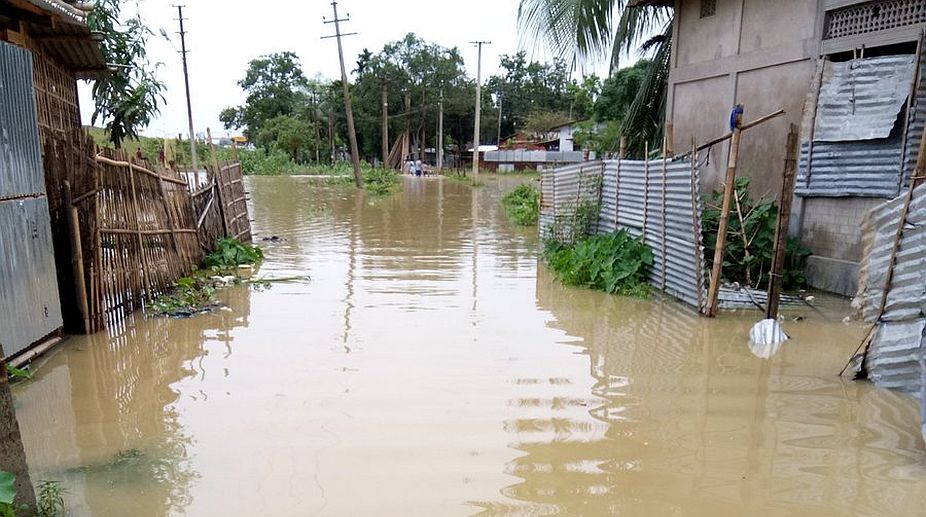
In 1863, J Fergusson of the Geological Survey of India called Assam “a region under the dominion of water”. That this observation is as valid today as it was then is clear when one looks at the staggering devastation the recent floods have caused in the region, especially in Assam.
The official death toll has been put at 60 but it could be much higher. Altogether 75 revenue circles in 25 out of 34 districts were under water. More than 1.7 million people were affected and about 24,000 took shelter in relief camps. Standing crops on 1.86 lakh hectares were damaged. Over half of the Kaziranga National Park was inundated with irreparable loss to wildlife.
As many as 58 districts in Assam, Arunachal Pradesh and Manipur reeled under flood waters and 80 people lost their lives. A clear picture of the damage is yet to emerge. It has prompted the Centre to engage the Indian Space Research Organisation to conduct a survey to get a real picture.
Advertisement
Assam chief minister Sarbananda Sonowal is right to urge the Union finance minister to release the Central share of Rs 1,138 crore for the flood management programme, pending for the last 10 years against 141 schemes.
The flood waters have started receding now and soon the ordeals the people suffered will be forgotten. One may ask whatever happened to the much-talked about Brahmaputra Board that was set up in 1980 under an Act of Parliament. Its avowed object was to evolve a sustainable answer to recurring floods. It is now under the Union ministry of water resources.
The Board’s jurisdiction covered seven North-east states, Sikkim and also a part of West Bengal, which means that apart from the Brahmaputra and Barak valley, a part of the Teesta Basin is also under its charge. The board has 21 members — four full-time and 17 part-time, including a representative each of the Union ministry for Development of the North-east region and the North Eastern Council. It has a provision for special invitees from all states concerned.
The Board started functioning from 1982 and, as per its charter, was to prepare master plans in three parts,
and in all 55 such for the tributaries of the Brahmaputra and the Barak and rivers of Tripura and Dhaleswari. There was a separate plan to protect Majuli, the world’s largest river island. By 1997, those master plans were approved and passed on to the state governments for implementation as part of their plans.
In Assam this formed the core of the “flood management programme” and in other North-east states too covered
activities like the construction, operations and maintenance of embankments and anti-erosion schemes .The Majuli island received special attention as its area had shrunk to 502 sq km in 2004 from its original area of 1,150 sq km. A sum of Rs 200.13 crore was allocated to raise and strengthen embankments and anti-erosion structures.
Several initiatives like the restoration of the Lohit and Dibang rivers and the Harrang drainage development schemes and establishment of the North-east Hydraulic and Allied Research Institute in 1996 indicated the importance attached by the Brahmaputra Board to develop a collaborative strategy for dealing with the floods with other states as partners.
The board is also an agency of the Union ministry of water resources as it identifies hydro-power potential of the region and facilitates multi-purpose “water resource development projects”.
Assam’s experience in the current season shows that unabated degradation of land, especially the wetlands, deforestation of the hills, construction of dams and hydel projects in the ecologically- sensitive areas, caused a
massive rise in siltation levels of all rivers, which in turn, led to erosion of river banks across the valley.
One must remember that the devastating 15 August 1950 earthquake in Assam raised he river bed of the Brahmaputra
to a critical level.
On 9 July, when water in the dam of the 405 MW Ranganadi hydropower project —a North-east Electric Power Corporation unit in Arunachal Pradesh — started overflowing, the dam authority, as a precautionary measure, released surplus water and that caused breaches in embankments and inundation of the district headquarters of North Lakhimpur.
It may be useful to look at the Brahmaputra closely. It originates from the Konglungkong glacier in Tibet at an elevation of 5,150 metres, traverses 1,625 km in Tibet, 918 in India (278 km in Arunachal Pradesh and 640 km in Assam) and 363 km in Bangladesh.
Twenty six tributaries on its north bank and 13 on the south, join the river. The annual flow of its water at Jogighopa is 573 BCM, on the Bangladesh border, which is 29 per cent of the total water flow of the country. In terms of the sheer volume of water the Brahmaputra carries (85 ha m per sq km), it is next only to theAmazon’s 87 ha m per sq km. It
encompasses a basin of 5.80 lakh sq km in South Asia.
The challenges of flood moderation of the val ley are, therefore. tremendous and require a sustainable development approach rather than an economic output-centric strategy with focus on hydel power development to meet the demand of areas and earn revenues. All this when the prime need is to conserve the ecosystem of the downstream areas.
Since such projects will invariably be in the hills, downstream plains will be at the receiving end. In this background
it is disquieting to note that Arunachal Pradesh government has signed memorandums of understanding
for 143 projects, for generating 46,442 MW.
Fifteen such projects are under construction (5,480 MW) in the North-east even though the Brahmaputra Board’s “flood management” projects in the Brahmaputra and Barak valley districts have produced virtually no significant impact on floods for want of, firstly, a scientific land use policy for urban and rural areas, and second a wrong perception that water is a “resource”in the economic and commercial sense and therefore should be exploited for profit. It is part of the ecology
and its sustainable use is critical for survival of the Earth.
It’s time now for the Centre and the states to review the performance of the Brahmaputra Board, its approach to recurring floods in the region and hydro power development, which looks like a zero sum game, and protect the wildlife, human habitat and life support system at the core of its strategy.
On the contrary, in its submissions before the Apex Court in Civil Appeal No 6736 of 2013, the Union ministry of water resources argued in favour of hydro-power projects, citing lower tariffs and capacity to provide “peaking power” while ignoring the fact that the “peaking hydropower would hold up water for 20 hours and thereby throttle the Brahmaputra” aspointed out by the petitioners against dams in the North- east.
Indeed, while estimating the hydel power potential, the adequacy of flow, longitudinal integrity of the river stream and the competing needs of society should be fully taken into account.
The All Assam Students’ Union’s demand for the declaration of recurring floods as a “national problem” is well-timed as it is verily a case of national failure and mis-governance of the environment.
(The writer is a retired IAS officer of the Assam-Meghalaya cadre and has served as a scientific consultant in the office of the principal scientific advisor to the government of India)
Advertisement